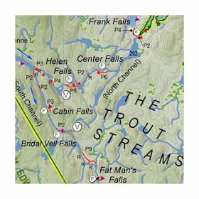
For the past two decades, the Friends of Temagami has been documenting, restoring and promoting lost, forgotten and underused canoe routes in Temagami. This map is the result of a comprehensive review of existing information coupled with on-the-ground explorations.
It is much more than a simple canoe routes map. The Adventurers’ Map shows over 4000 km of canoe routes,1450 portages, 1100 campsites, 53 access points and 40 viewpoints. It also shows 14 provincial parks, 21 conservation reserves and 10 hiking trail networks. Uniquely, it includes paleo-historic points of interest, field notes highlighting special features, and over 30 significant and accessible stands of old growth pine forest. There are also a number of previously unpublished routes and other hidden gems.
The map shows two categories of portages: In Use and Other. Most travellers will be able to find and follow In Use Portages, though the trail quality may vary widely. Other Portages may be overgrown, destroyed by logging or other development (unknown) — some will be passable, others will not.
This large-scale map is ideal as a route planner. It is not intended for navigation. We suggest that you use this map in conjunction with 1:50,000 topographic maps while on trip. Lines on the map help you determine which topo maps you will need.
Dimensions: 107cm x 132cm
| Specifications | |
|---|---|
| SKU | FOT-T-2 |


